
By Don Iannone
The Cleveland Civil War Roundtable
Copyright © 2026, All Rights Reserved
Editor’s note: This article was originally published in The Charger in April 2026.
The American Civil War is often remembered through movement. Armies advance, lines break, and commanders maneuver across contested ground. Beneath these visible actions lay a quieter discipline that made such movement possible. Cartographers, working as topographical engineers, surveyors, and mapmakers, translated uncertain terrain into usable knowledge. Their work shaped strategy, influenced outcomes, and helped define how the war would be remembered.
These men did more than record geography. They interpreted it. In doing so, they imposed order on chaos, sometimes accurately, sometimes imperfectly, but always with consequence.
The Cartographer’s Role in Civil War Armies
Cartographers were essential to both Union and Confederate military operations. Their primary task was to gather and represent geographic information such as roads, rivers, elevations, vegetation, and settlements. These features were not merely descriptive. They were tactical.
The Union benefited from the prewar establishment of the U.S. Army Corps of Topographical Engineers, staffed largely by West Point graduates trained in mathematics, engineering, and surveying.1 These officers conducted reconnaissance, prepared maps, and advised commanders on terrain. Their work was integrated into planning at every level of command.
The Confederacy began the war with fewer resources and limited access to reliable maps. Early in the conflict, Southern leaders recognized that existing cartographic knowledge was inadequate.2 Efforts were made to organize mapping bureaus and gather geographic intelligence, often under difficult conditions and with limited equipment.3
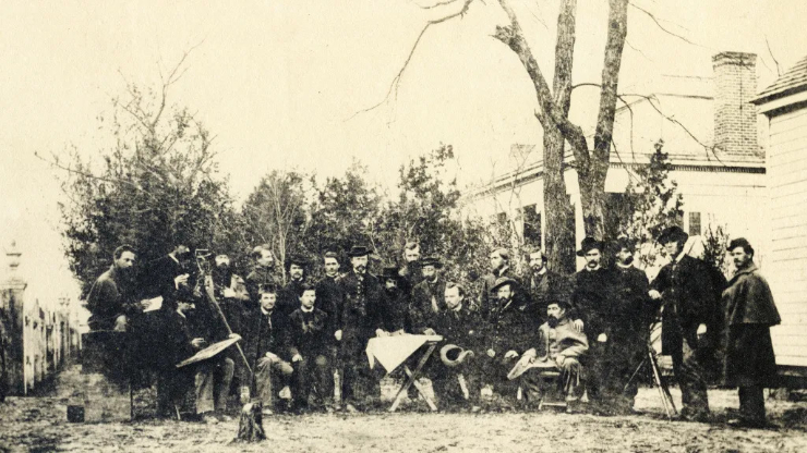
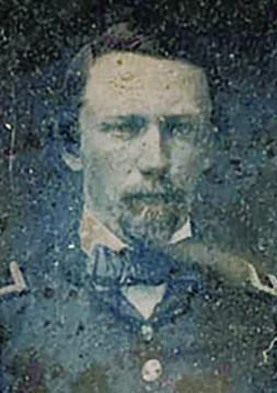
William Merrill, who is discussed later in this article, is standing to the left of the table with his hand on the table.
In both armies, cartographers frequently operated near the front. They observed terrain under fire, interviewed local residents, and created sketches that were later refined into working maps. These maps guided troop movements, identified defensible ground, and allowed separated units to coordinate across unfamiliar landscapes.
Terrain and the Nature of the War
The Civil War was deeply shaped by terrain. Success often depended on understanding the land as much as on leadership or numbers.
Armies rarely moved as a single mass. They advanced along multiple roads and required careful coordination. Without accurate maps, units could become lost, delayed, or exposed.4 This challenge was especially acute for Union forces operating in Southern territory, where local knowledge often favored Confederate defenders.5
Cartographers attempted to bridge this gap. They gathered information from observation, existing surveys, and civilian sources. The resulting maps were often incomplete, but they provided a framework for decision-making in an environment defined by uncertainty.
Training and Background
Civil War cartographers came from diverse backgrounds. Many Union officers were formally trained at West Point, where instruction in topography and engineering prepared them for technical service.6 These men brought a level of precision and discipline to mapmaking that reflected their education.
Others entered the field through informal means. Jedediah Hotchkiss, one of the Confederacy’s most important mapmakers, had no formal training. A schoolteacher by profession, he developed his skills independently.7 His success demonstrates that practical experience and careful observation could rival formal instruction.
This range of training contributed to variation in map quality. Some maps were highly detailed and accurate. Others relied on estimation or incomplete data. Yet even imperfect maps could be decisive when no better information was available.
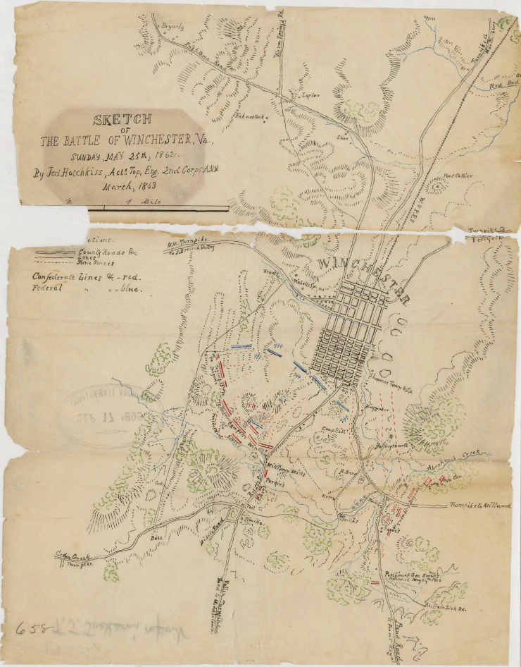
Jedediah Hotchkiss and the Shenandoah Valley
Jedediah Hotchkiss remains the most celebrated Civil War cartographer. Serving under Stonewall Jackson, he was tasked with mapping the Shenandoah Valley, a region central to Confederate operations.
Jackson instructed him to prepare a map showing all points of offense and defense.8 The result was a detailed and highly functional representation of the Valley’s terrain. It enabled Jackson to move rapidly and unpredictably during the Valley Campaign of 1862.9
Hotchkiss’s work illustrates the direct connection between cartography and military success. His maps did not simply describe the landscape. They allowed commanders to use it effectively.
Union Cartographers and Ohio Connections
The Union produced a number of distinguished cartographers and engineers, many with ties to Ohio and the broader Midwest. Gouverneur K. Warren, a West Point-trained engineer, played a critical role in reconnaissance and mapping. His keen understanding of terrain at Gettysburg led him to identify the strategic importance of Little Round Top, a position central to Union success.10 Cleveland S. Rockwell, though born in Connecticut, worked within Northern engineering networks that included Ohio officers. His coastal surveys strengthened the Union blockade by improving its ability to intercept Confederate shipping.11
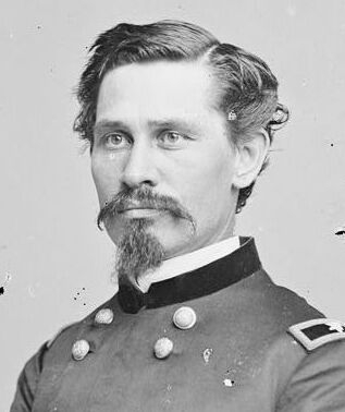
Ohio itself contributed a substantial corps of technically trained officers who served in mapping and engineering roles. The state’s educational institutions and its deep involvement in the Union war effort made it a consistent source of such expertise, while Cleveland’s role as a center of commerce and communication supported the production and circulation of maps for military and civilian use. This contribution is evident in figures such as Orlando M. Poe of Navarre, Ohio, who served as chief engineer in the Army of the Tennessee and produced maps and fortifications that shaped campaigns from Vicksburg to Sherman’s March to the Sea, and William E. Merrill, who carried out similar reconnaissance and engineering work in the Western Theater.
Ohio soldiers in the field depended on these efforts. Letters and diaries from Ohio regiments frequently reveal a close attention to roads, elevations, and movement, reflecting a reliance on cartographic knowledge even when that information was incomplete.12
Cartographers and Photographers
One of the most intriguing aspects of Civil War documentation is the relationship between cartography and photography. While these disciplines were distinct, they often complemented one another.
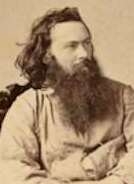
Photographers such as Mathew Brady, Alexander Gardner, and Timothy O’Sullivan captured images of battlefields, fortifications, and landscapes. These photographs provided visual records that could be used to confirm or refine cartographic work.13
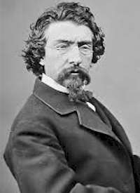
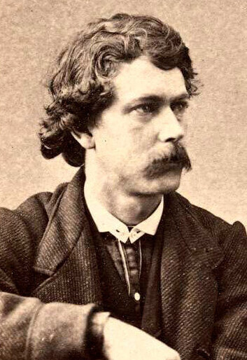
Timothy O’Sullivan, in particular, had experience as both a photographer and a survey assistant. After the war, he participated in western surveys where photography and mapping were closely integrated.14 His Civil War photographs, though limited in scope compared to later work, reflect an emerging connection between visual documentation and geographic analysis.
Photographs helped cartographers understand features that might be difficult to capture in sketches alone. They provided detail on terrain, structures, and the aftermath of battle. However, photography had limitations. Exposure times and equipment constraints meant that images were often staged or taken after the fighting had ended.
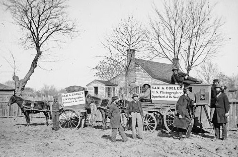
As a result, maps and photographs offered different kinds of truth. Maps emphasized structure and movement. Photographs captured moments and physical reality. Together, they contributed to a more complete understanding of the battlefield.
The Consequences of Imperfect Maps
Inaccurate maps could create serious vulnerabilities. Early in the war, both sides suffered from a lack of reliable cartographic information. Existing maps were often outdated or incomplete, missing critical details such as minor roads or changes in terrain.15
These deficiencies could lead to misdirected movements and coordination failures. Units might arrive late to a planned engagement or advance along exposed routes. In some cases, commanders made decisions based on incorrect assumptions about the landscape.
Even later in the war, when mapping had improved, uncertainty remained. Cartographers worked under pressure and often relied on estimation. Errors were inevitable. A slight misjudgment in elevation or distance could alter the effectiveness of artillery or the timing of an attack.
These vulnerabilities highlight the importance of cartographic accuracy. They also underscore the limits of knowledge in wartime. Maps could guide action, but they could not eliminate uncertainty.
Cartography and the Postwar Record
The influence of Civil War cartographers extended far beyond the battlefield. Their maps became foundational documents in the effort to record and interpret the war.
The Official Records of the War of the Rebellion relied heavily on wartime maps. These maps, often revised and standardized, shaped how battles were described and understood. In many cases, they became the authoritative representation of events.
Hotchkiss’s maps provide a striking example. After the war, Union authorities recognized their value and incorporated them into official materials.16 This adoption reflects the degree to which cartographic accuracy could transcend sectional divisions.
At the same time, the process of publication introduced a sense of finality. Field sketches that had once been tentative were transformed into clean, authoritative images. Uncertainty was reduced. Complexity was simplified.
In this way, cartographers helped construct Civil War memory. Their work influenced historians, veterans, and the public. The lines they drew became part of the narrative of the war itself.
Conclusion
Civil War cartographers occupied a position of quiet but profound influence. They did not lead charges or command armies, yet their work shaped both action and interpretation. Through their maps, they made the landscape legible. They enabled movement, guided strategy, and influenced outcomes. After the war, they helped define how events would be remembered.
Their work was never purely objective. It reflected training, judgment, and the limitations of perception. The maps they produced were interpretations as much as representations.
The Civil War was fought across fields and rivers, but also across lines drawn by human hands. In those lines, the war found direction, and later, meaning.
How to Learn More
For readers interested in exploring Civil War cartography further, several resources offer valuable insight:
- Earl B. McElfresh’s Maps and Mapmakers of the Civil War provides a comprehensive overview of cartographic practices and figures.
- The Library of Congress houses the Hotchkiss Map Collection, available online and in person, offering detailed examples of Confederate mapping.
- The National Park Service provides accessible biographies and battlefield studies that highlight the role of terrain.
- The Western Reserve Historical Society in Cleveland contains regional materials that illuminate Ohio’s contribution to the war, including maps and personal papers.
- Visiting preserved battlefields such as Antietam or Gettysburg allows one to see firsthand the terrain that cartographers attempted to capture.
Engaging with these materials reveals not only the technical skill involved in Civil War cartography but also its enduring significance.
Footnotes (Click on the book links on this page to purchase from Amazon. Part of the proceeds from any book purchased from Amazon through the CCWRT website is returned to the CCWRT to support its education and preservation programs.)
1Earl B. McElfresh, Maps and Mapmakers of the Civil War (New York: Harry N. Abrams, 1999), 15–18.
2Ibid., 30–32.
3Clara LeGear, “The Hotchkiss Collection of Confederate Maps,” Library of Congress.
4McElfresh, Maps and Mapmakers of the Civil War, 42–45.
5Ibid., 50–55.
6Ibid., 18–22.
7Brandi K. Oswald, “Jedediah Hotchkiss: Mapmaker of the Confederacy,” National Archives.
8Jedediah Hotchkiss, quoted in Library of Congress.
9National Park Service, “Jedediah Hotchkiss.”
10McElfresh, Maps and Mapmakers of the Civil War, 120–125.
11Civil War Correspondence Collection, Mahn Center for Archives and Special Collections, Ohio University Libraries; see also George Benson Fox Letters, Cincinnati History Library and Archives; Earl J. Hess, The Union Soldier in Battle: Enduring the Ordeal of Combat (Lawrence: University Press of Kansas, 1997), 63–68.
12Ibid., 210–215.
13William A. Frassanito, Gettysburg: A Journey in Time (New York: Scribner, 1975).
14Martha A. Sandweiss, Print the Legend: Photography and the American West (New Haven: Yale University Press, 2002).
15McElfresh, Maps and Mapmakers of the Civil War, 60–65.
16Ibid., 243–245.